| Objectives & Results |
|
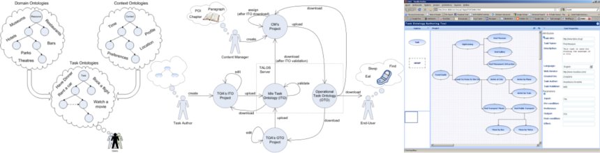
The project has the following major achievements. ContextA Context aggregation module which captures the user’s contextual attributes was implemented. It does so using the following components:
Task ComputingThe Task Ontoloy Authoring Tool (TOAT) relies on a formal model that is used for describing the various tasks of the end-users in the context of TALOS. Examples of task scenarios regarding the use case of a mobile traveller have been created within TOAT based on actual surveys. The interface and the functionalities of TOAT are based (a) on the results of actual surveys involving both expert and non-expert users, and (b) on the requirements defined by the SMEs. TOAT has been implemented following the principles of the overall architecture of the TALOS system.
Content and MetadataA content repository has been implemented that allows for efficient manipulation of content to provide it for whatever device and form necessary. This repository includes a content conversion methodology and database-based content repository. A Web-based content manipulation interface for the repository provides the basic means for any content manipulation as well as metadata authoring including annotation of content with tasks. Specifically, the interface includes/consists of
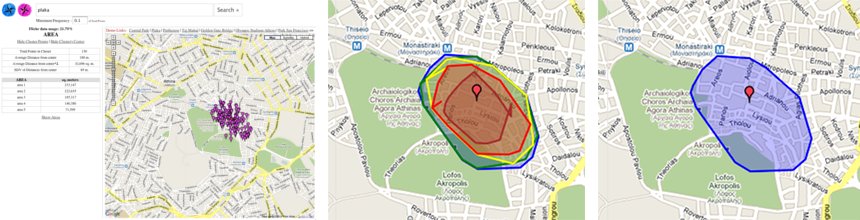
Beyond this effort, various open-source geospatial data sources have been explored, e.g., Muselia, ChefMoz, dbpedia, booking.com and been integrated as metadata sources in the Web-based content authoring tool. In addition and based on feedback collected during the project, geospatial content creation tools were developed. The objective is to use massive amounts of user-contributed data of low accuracy as input, fuse this data and generate geospatial data of higher quality as output. The example shown, depicts the are of Plaka in Athens as extracted from geocoded flickr images. It is worth noting that no official record of this area exists and the developed method among other things establishes the bounds of this area.
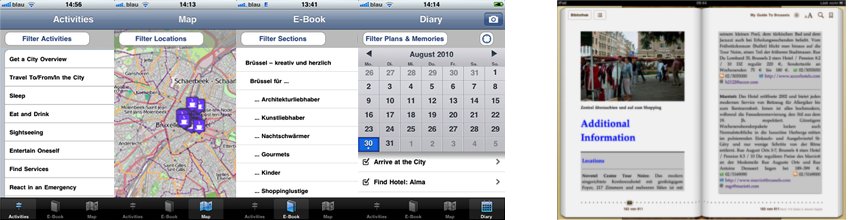
ProtoypesThe above components and their outputs have been put together forming the TALOS system. The TALOS system has two output channels, which result in two prototypes, namely a task-aware travel guide, in an eBook form, and a mobile travel guide, designed for the Apple iPhone platform. The first prototype is a portal Web site that allows travelers to buy or select a MMV travel guide of their choice. It allows the traveler to save additional content from the Web to his or her personal space, tag the additional content with relevant tasks and add the tagged content to the travel guide. The travel guide including additional content can then be downloaded as an eBook or used in the iPhone app.
The second prototype consists of a mobile travel guide for the iPhone platform. The mobile travel guide offers data extracted from the back-end server in various representations, through task-based interfaces. The fact that available content is organized around tasks, in combination with the exploitation of the user’s context leads to efficient and personalized content provision. The mobile travel guide includes four modes of operation, namely, the activities, eBook, map, and diary mode.
|


